Jeffrey Varga

Located in Corvallis, OR
Professional Summary
GIS Analyst experienced in municipal planning support, housing needs analysis, and applied spatial modeling for public-sector decision-making. Experienced in spatial analysis, network modeling, geospatial data management, and cartographic communication. Produces GIS outputs that translate complex datasets into actionable insights for planners, advisory committees, and stakeholders in Oregon land use contexts.
About Me
Hello! My name is Jeffrey Varga. I am a recent graduate of Oregon State University with a degree in Geospatial Science, alongside a completed degree in Piano Performance. I also hold GIS certifications, reflecting a focused and applied background in geospatial analysis.
My interest in GIS began through an introductory cartography course and quickly developed into a central academic and professional focus. Since then, I have built experience across spatial modeling, remote sensing, network analysis, 3D visualization, and Web GIS, with an emphasis on integrating complex datasets and developing structured analytical workflows.
Professionally, I have worked as a GIS Analyst with the City of Eugene Planning and Development Department, where I supported municipal planning through spatial analysis, data management, and applied research. My work included developing a network dataset in ArcGIS Network Analyst to evaluate housing accessibility, integrating housing and demographic datasets for contextualized housing need analysis, and performing quality control on the City’s Historic and Cultural Resources database.
My project work further reflects this applied focus. Recent projects include modeling dust dispersion from the shrinking Great Salt Lake using LiDAR and atmospheric data, and conducting network-based evacuation analysis to identify optimal vertical evacuation structure locations for the Ocean Shores community in Washington.
Outside of GIS, I am a classically trained pianist with extensive solo and collaborative performance experience. I am also an Eagle Scout and a recipient of the Vigil Honor.
View my complete GIS experience here. Curriculum Vitae →
Featured Projects
A few recent projects of mine. See all projects →
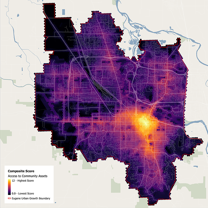
Housing Accessibility Network Model
Developed a network dataset in ArcGIS Network Analyst to evaluate housing accessibility across Eugene, integrating housing and demographic datasets for contextualized planning analysis.
Great Salt Lake Dust Dispersion Model
Modeled dust dispersion from the shrinking Great Salt Lake using LiDAR and atmospheric data interpolation to assess health and environmental risk across surrounding communities.